Comoros Volcanoes
-
Karthala
-

Karthala
-
Karthala
-
Karthala
-
Karthala
-
Karthala
-
Karthala
-
Karthala
-
Karthala
-

Karthala
-
Karthala
-
Karthala
-
Karthala
-
Karthala
-
Karthala
-
Karthala
-
Karthala
-
Karthala
-
Karthala
-
La Grille
Comoros has 2 Holocene volcanoes. Note that as a scientific organization we provide these listings for informational purposes only, with no international legal or policy implications. Volcanoes will be included on this list if they are within the boundaries of a country, on a shared boundary or area, in a remote territory, or within a maritime Exclusive Economic Zone. Bolded volcanoes have erupted within the past 20 years. Suggestions and data updates are always welcome ().
Chronological listing of known Holocene eruptions (confirmed or uncertain) from volcanoes in Comoros. Bolded eruptions indicate continuing activity.
| Volcano Name | Start Date | Stop Date | Certainty | VEI | Evidence |
|---|---|---|---|---|---|
| Karthala | 2007 Jan 12 | 2007 Jan 15 (?) | Confirmed | 2 | Observations: Reported |
| Karthala | 2006 May 28 | 2006 Jun 3 (?) | Confirmed | 0 | Observations: Reported |
| Karthala | 2005 Nov 24 | 2005 Dec 8 | Confirmed | 3 | Observations: Reported |
| Karthala | 2005 Apr 16 | 2005 Apr 18 | Confirmed | 2 | Observations: Reported |
| Karthala | 1991 Jul 11 | 1991 Jul 11 | Confirmed | 2 | Observations: Reported |
| Karthala | 1977 Apr 5 | 1977 Apr 10 | Confirmed | 1 | Observations: Reported |
| Karthala | 1972 Sep 8 | 1972 Oct 5 | Confirmed | 1 | Observations: Reported |
| Karthala | 1965 Jul 12 | 1965 Jul 12 | Confirmed | 2 | Observations: Reported |
| Karthala | 1956 Jun 1 (?) | Unknown | Confirmed | 2 | Observations: Reported |
| Karthala | 1952 Feb 10 (?) | 1952 Feb 12 | Confirmed | 2 | Observations: Reported |
| Karthala | 1948 Apr 22 | 1948 Jun 16 | Confirmed | 2 | Observations: Reported |
| Karthala | 1928 ± 2 years | Unknown | Confirmed | 1 | Observations: Reported |
| Karthala | 1918 Aug 11 | 1918 Aug 26 | Confirmed | 3 | Observations: Reported |
| Karthala | 1910 Mar | 1910 Mar | Confirmed | 1 | Observations: Reported |
| Karthala | 1904 Feb 25 | 1904 Apr | Confirmed | 2 | Observations: Reported |
| Karthala | 1883 Mar | 1884 | Confirmed | 2 | Observations: Reported |
| Karthala | 1880 | Unknown | Confirmed | 2 | Observations: Reported |
| Karthala | 1876 | Unknown | Confirmed | 0 | Observations: Reported |
| Karthala | 1872 | Unknown | Confirmed | 2 | Observations: Reported |
| Karthala | 1865 | Unknown | Confirmed | 2 | Observations: Reported |
| Karthala | [1862] | [Unknown] | Uncertain | ||
| Karthala | 1860 Dec 29 | Unknown | Confirmed | 0 | Observations: Reported |
| Karthala | 1859 | Unknown | Confirmed | 2 | Observations: Reported |
| Karthala | 1858 | Unknown | Confirmed | 2 | Observations: Reported |
| Karthala | 1857 | Unknown | Confirmed | 2 | Observations: Reported |
| Karthala | 1855 Jul 1 ± 30 days | Unknown | Confirmed | 2 | Observations: Reported |
| Karthala | 1850 (?) | Unknown | Confirmed | 0 | Observations: Reported |
| Karthala | 1848 | Unknown | Confirmed | 0 | Observations: Reported |
| Karthala | 1833 | Unknown | Confirmed | Observations: Reported | |
| Karthala | 1830 | Unknown | Confirmed | 2 | Observations: Reported |
| Karthala | 1828 May | Unknown | Confirmed | 2 | Observations: Reported |
| Karthala | 1821 Dec 31 ± 365 days | Unknown | Confirmed | Observations: Reported | |
| Karthala | 1814 Dec 31 ± 365 days | Unknown | Confirmed | Observations: Reported | |
| Karthala | 1808 | Unknown | Confirmed | Observations: Reported | |
| Karthala | 1050 ± 150 years | Unknown | Confirmed | Observations: Reported |
Comoros has 2 Pleistocene volcanoes. Note that as a scientific organization we provide these listings for informational purposes only, with no international legal or policy implications. Volcanoes will be included on this list if they are within the boundaries of a country, on a shared boundary or area, in a remote territory, or within a maritime Exclusive Economic Zone. Suggestions and data updates are always welcome ().
| Volcano Name | Location | Primary Volcano Type |
|---|---|---|
| Anjouan Island | Indian Ocean (western) | Shield |
| Moheli Island | Moheli Island (Comoros) | Shield |
There are 20 photos available for volcanoes in Comoros.
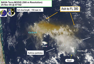 An image of the Karthala 25 November 2005 ash plume was obtained from NASA Terra MODIS. The image was centered over the Comoros islands and also shows Mayotte, Anjouan, and Moheli islands. Grand Comore is under the ash plume but the location of Karthala is indicated. For scale, the distance from Karthala to the south end of Mayotte Island is ~240 km. The image shows Air Force Weather Agency interpretations of the ash cloud extent.
Image courtesy of Charles Holliday (U S Air Force Weather Agency).
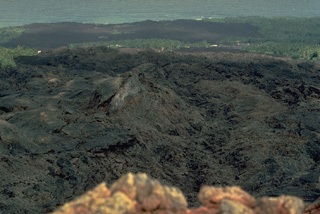
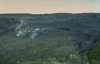
 An eruption during September 8-October 5, 1972 occurred from four fissures in the summit caldera of Karthala. Lava flows from the initial stage of the eruption covered the northern caldera floor and traveled through the northern gap in the caldera rim (upper right) 2 km down the NW flank. From September 9 to 12, activity was restricted to a cinder cone (foreground) immediately north of the Choungou Chagnoumeni pit crater. Renewed activity September 13-15 produced lava flows that traveled 4-5 km down the NW flank.
Copyrighted photo by Katia and Maurice Krafft, 1980.
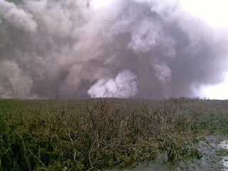
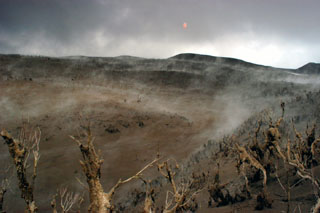 Tephra deposits left by Karthala's 16-18 April 2005 eruption altered the landscape and destroyed vegetation. This picture was taken at the entrance to the first caldera on the western trail, viewed looking to the S. A brief eruption from Chahalé crater beginning on the 16th produced ashfall that increased in intensity the following day, producing an ash plume and volcanic lightning. Ash deposits varied in thickness from a few millimeters on the coast to ~1.5 m at the summit.
Photo by Nicolas Villenueve, 2005 (Université de la Réunion).
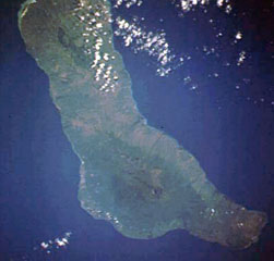 Grand Comore Island in the Indian Ocean NW of Madagascar is formed by two massive shield volcanoes. The more well-known and historically active Karthala volcano at the southern end of the island has a 3 x 4 km summit caldera. Elongated rift zones extend to the NNW and SE; the lower SE rift zone forms the Massif du Badjini, a peninsula at the SE tip of the island (bottom right). The Holocene La Grille volcano forms the northern part of the island. Youthful lava flows from both volcanoes have reached the coast.
NASA Space Shuttle image STS009-39-2516, 1983 (http://eol.jsc.nasa.gov/).
 A black basaltic lava flow originating in 1977 from the SW-flank cinder cone in the foreground cut the main west-side highway on Karthala Island, partially destroying about 300 houses in two villages along the road 1 km below the vent. After diverging around a vegetated kipuka, the flow reached the sea along a 1.5-km-long front. Ashfall from the April 5-10, 1977 eruption also damaged the village of M'Djoyezi, which was located 1 km west of the vent.
 Copyrighted photo by Katia and Maurice Krafft, 1980.
 An eruption from a SW-flank fissure beginning April 5, 1977 produced a lava flow that reached the sea and destroyed or damaged villages located along the E-W-trending road cutting across the center of the photo. The 5-day-long eruption originated from a cinder cone constructed along a vent at 360-m altitude. The basaltic lava flow traveled about 2 km and reached the sea along a 1.5-km-long front. About 300 houses were destroyed in the villages of Singani (left) and Hesa (right). The flow diverged around a vegetated kipuka, sparing houses there.
Copyrighted photo by Katia and Maurice Krafft, 1980.
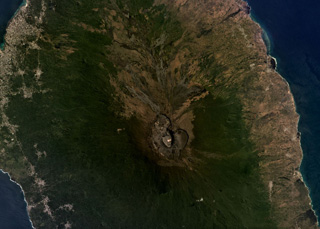 Karthala shield volcano forms the southern two-thirds of Grand Comore Island, NW of Madagascar in the Indian Ocean. The summit caldera is near the center of this August 2019 Planet Labs satellite image monthly mosaic (N is at the top; this image is approximately 25 km across). Lava flows reach the ocean on both sides from summit and flank vents, and rift zones propogate to the SE and NW from the caldera.
Satellite image courtesy of Planet Labs Inc., 2019 (https://www.planet.com/).
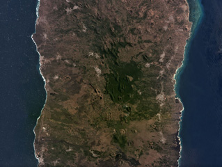 La Grille shield volcano forms the northern third of Grand Comore Island NW of Madagascar, with the larger Karthala forming the southern portion. The island is around 15 km wide in the area pictured. Numerous scoria cones can be seen across the summit region and flanks in this September 2019 Planet Labs satellite image monthly mosaic (N is at the top. Several tuff rings have formed along the northern coast.
Satellite image courtesy of Planet Labs Inc., 2019 (https://www.planet.com/).
 The greenish ~300-m-diameter Chahalé crater lake in the summit caldera complex of Karthala volcano is seen here in August 2003 before an eruption in April 2005. The photo, taken by an automatic camera located at the summit, looks from the NNE towards the SSW. Karthala is the southernmost and largest of the two shield volcanoes forming Grand Comore Island (also known as Ngazidja Island) and contains a 3 x 4 km summit caldera generated by repeated collapse. It has elongated rift zones extending to the NNW and SE.
Photo by Nicolas Villenueve, 2003 (Université de la Réunion).
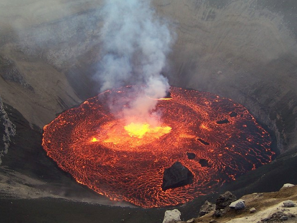
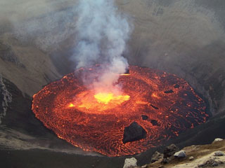
 On 18 April 2005 a lava lake formed in the Chahalé crater, previously occupied by a crater lake. In this aerial photo, taken from the N on the morning of the 18th, considerable portions of the lava lake's surface still remained molten and incandescent. The lake's surface only remained molten only for a few hours, and by the next day its chilled surface emitted only gas plumes.
Photo by Hamid Soulé, 2005 (Karthala Volcano Observatory).
 This 19 April 2005 aerial photograph of the Karthala Chahalé crater was taken from the SE. The surface of the lava lake, which had been emplaced the day before, had chilled and was emitting a white plume. Much of the summit area displays recently-deposited tephra from explosive eruptions on the 16th and 17th.
Photo by Nicolas Villenueve, 2005 (Université de la Réunion).
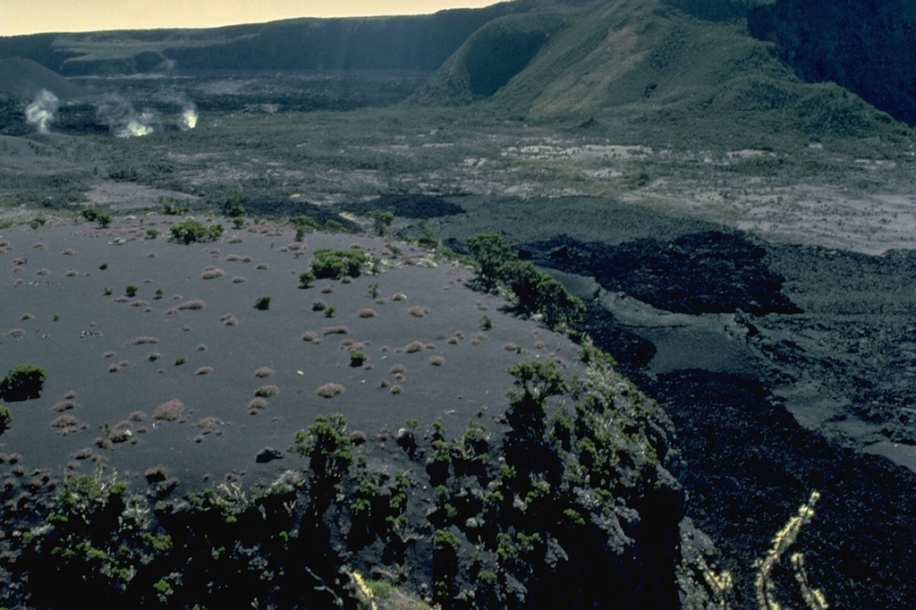
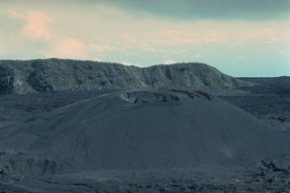
 The 250-m-wide Chongou-Chagnoumeni pit crater (center) cuts the northern part of the compound summit caldera of Karthala volcano. The steaming 30-m-deep pit crater was formed during an eruption in 1918 that also greatly enlarged the Chongou-Chahale pit crater to the south. Unvegetated lava flows from the 1972 eruption cover the caldera floor behind the pit crater.
Copyrighted photo by Katia and Maurice Krafft, 1980.
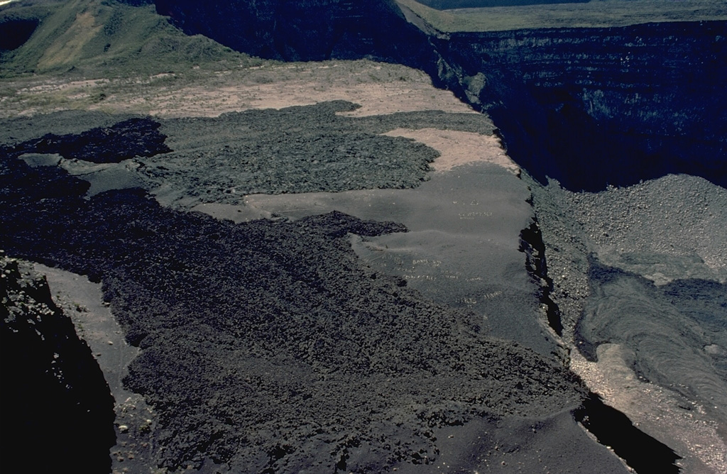
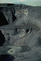
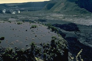
 The west rim of the summit caldera provides a view of two lava flows that traveled across a bench on the caldera floor. The darker flow in the foreground was produced during an eruption in 1972. It partially overrode the gray-colored flow beyond it produced in a 1965 eruption. Both flows traveled across the broad bench, one of four large platforms within the caldera, before dropping to the lower floor of the Choungou-Chahale caldera. The morphology of the compound, 3 x 4 km summit caldera has frequently been modified during historical eruptions.
Copyrighted photo by Katia and Maurice Krafft, 1980.
 Karthala, the largest of the two shield volcanoes forming Grand Comore Island, contains a compound 3 x 4 km summit caldera. The strombolian cinder cone on the floor of the steep-walled, 300-m-deep Choungou-Chahale caldera, seen here from the north, is surrounded by lava flows from the 1965 and 1972 eruptions. Elongated rift zones extend to the NNW and SE from the summit of the volcano. More than twenty eruptions have been recorded since the 19th century from both summit craters and flank vents.
Copyrighted photo by Katia and Maurice Krafft, 1980.
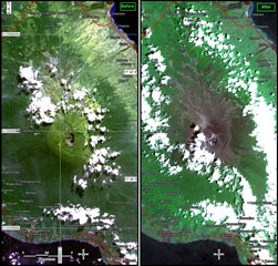 Karthala is seen in two images (10-m resolution) at nearly the same scales. The left image was acquired before the 2005 eruptions by SPOT4 on 13 July 2004. The right image is from after the 24 November 2005 eruption, taken by SPOT5 on 5 December 2005. Both images are partly masked by clouds. The right-hand photo shows ashfall deposits from the April and November eruptions blanketing the summit caldera and upper flanks.
Photo courtesy of United Nations, 2005 (UNOSAT)
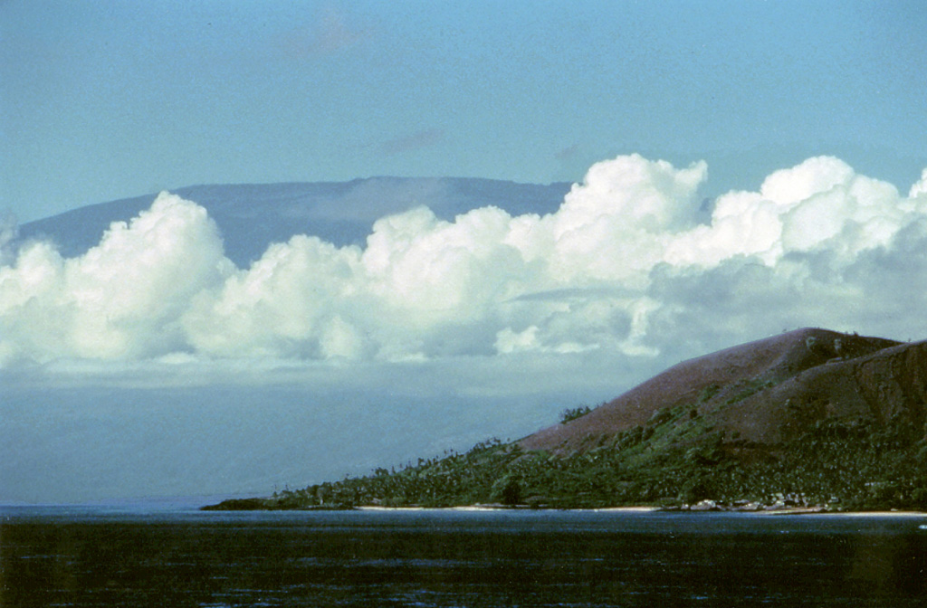
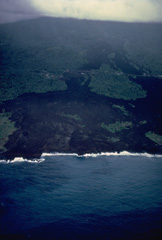
 Clouds cover the flanks of the Karthala shield volcano at the S end of Grand Comore Island. A scoria cone of the northern La Grille shield volcano is on the coast in the foreground. Karthala contains a 3 x 4 km summit caldera and elongated rift zones that extend to the NNW and SE from the summit. More than twenty eruptions have been recorded at Karthala since the 19th century, but no historical eruptions are known from La Grille volcano.
Copyrighted photo by Stephen and Donna O'Meara, 2002.
 Steam rises from fumaroles at the margins of the Choungou-Chagnoumeni pit crater in the summit caldera of Karthala volcano. This 1980 view from the SSE shows black lava flows from the 1972 eruption and gray lava flows from the 1965 eruption on the caldera floor at the lower right.
Copyrighted photo by Katia and Maurice Krafft, 1980.
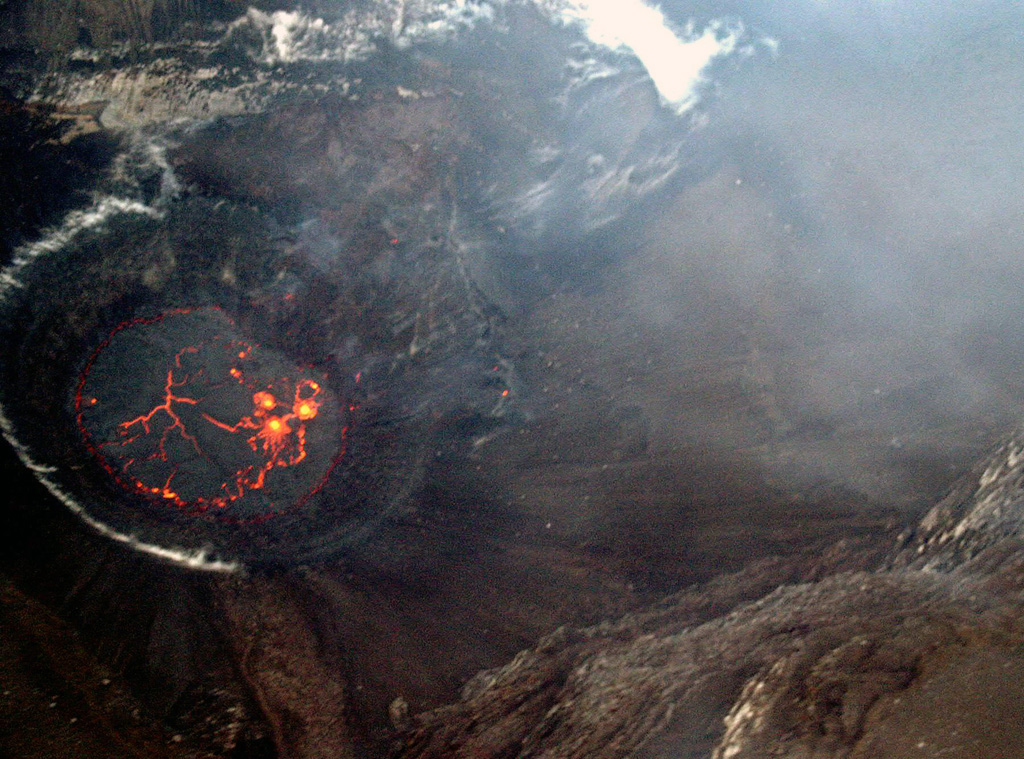
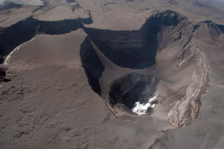
 An explosive eruption on 24-25 November 2005 deposited ash over the SE and SW parts of Grand Comore Island in the Indian Ocean (also known as Ngazidja Island). Ashfall occurred in Moroni, the capital city of the Comoros, located on the W-central coast. On 26 November this incandescent lava lake was observed inside Chahalé crater within the summit caldera of Karthala volcano. Within a few days the surface of the 60-80-m-wide lava lake had mostly solidified, and the eruption ended on 8 December.
Photo by Christophe Roche, 2005.
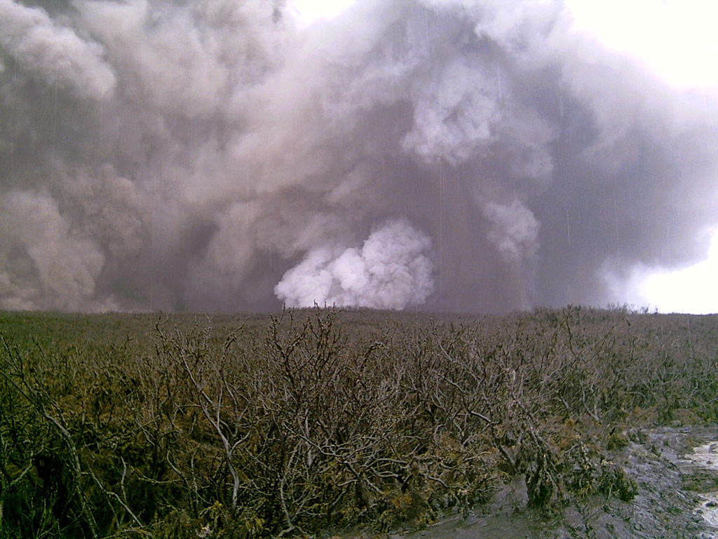
 A phreatic eruption plume is seen from Karthala's E slopes on the afternoon of 17 April 2005. The vent lies below the white-plume in the center of the photo. A brief explosive eruption beginning on 16 April and produced ashfall that increased in intensity the following day. On the 18th a lava lake was seen in the crater and the surface had cooled by the following day.
Photo by Daniel Hoffschir, 2005.
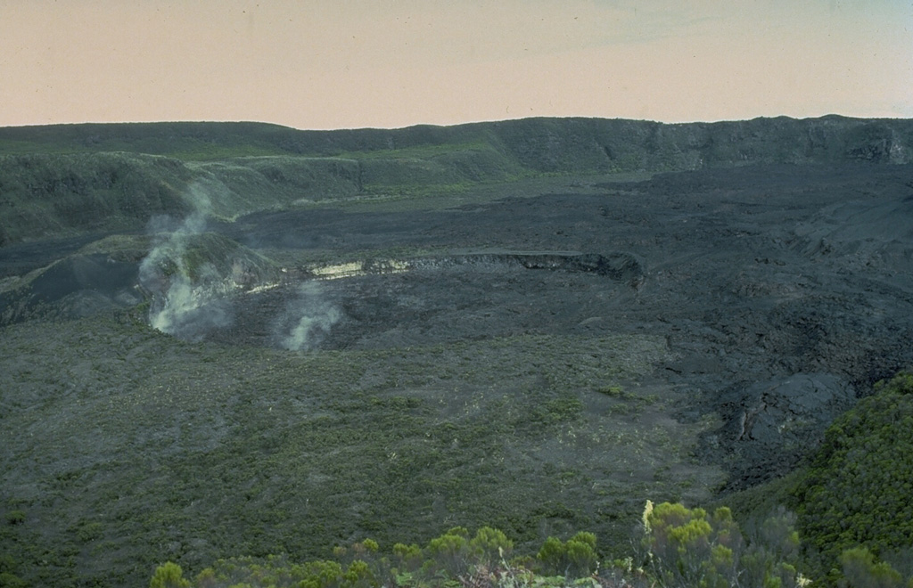
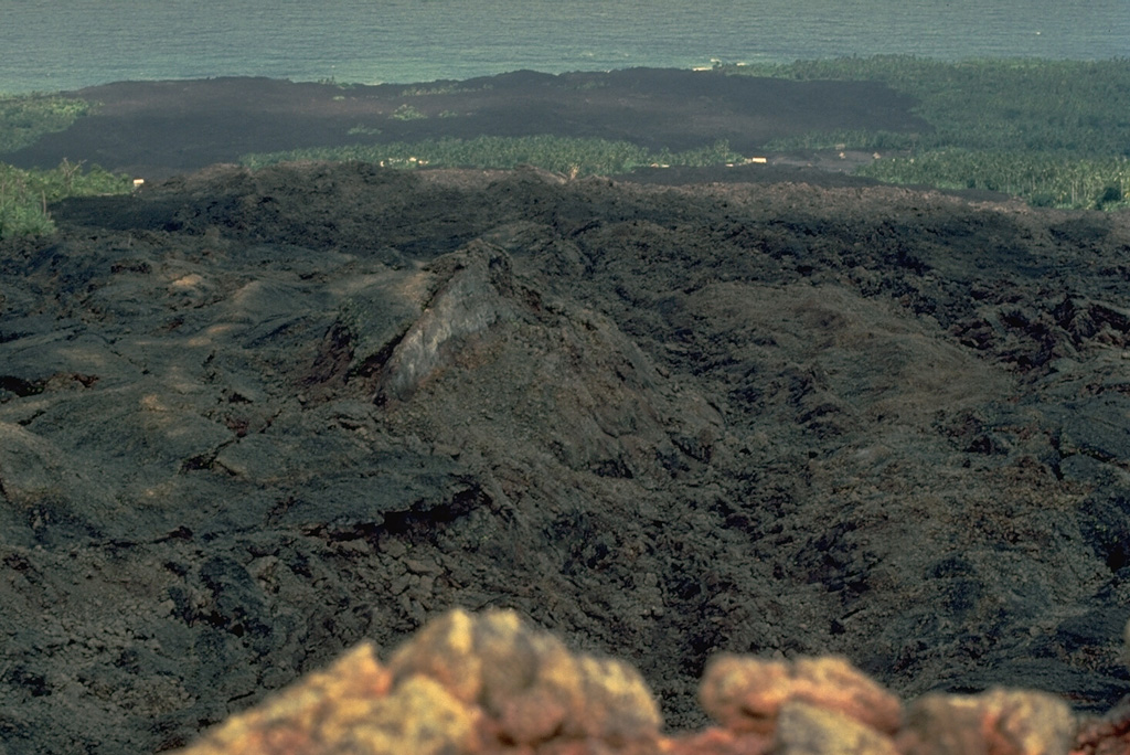
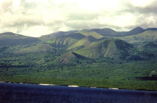 Cones can be seen here on the flanks of La Grille shield volcano at the N end of Grand Comore Island (also known as Ngazidja). It is located N of Karthala volcano, and the scoria cones reach up to 800 m in height. Recent lava flows, some perhaps as young as a few hundred years, have reached the sea from fissures on the lower W, N, and E flanks.
Copyrighted photo by Stephen and Donna O'Meara, 2002.
This is a compilation of Comoros volcano information sources, such as official monitoring or other government agencies.
| Volcano Observatories | |
|---|---|
| Centre National de Documentation et de Recherche Scientifique (CNDRS) | |
| Civil Protection Agencies | |
|---|---|
| Direction Générale de la Sécurité Civile – Comores | |
| Volcanic Ash Advisory Center | |
|---|---|
| Toulouse Volcanic Ash Advisory Center (VAAC) Notices and Archive | |